
Monday, October 13, 2008
Highly Eliptical orbit (HEO)
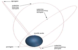
HEO is an orbital satellite that is more than 36.000 Km from the surface bumi. This orbit is the most distant orbital distance from the other. Highly Eliptical orbit was developed by Russia.

Thursday, October 9, 2008
Medical Equipment
Some days I surf, I find affiliate programs in the field of health care equipment sales. Many products are offered with prices that vary.
You can have medical equipment to health or to be sold on the customers. If you want to buy or join as affiliates in this program please sigup. Get discounts and also get a commission of 5% of your sales.

You can have medical equipment to health or to be sold on the customers. If you want to buy or join as affiliates in this program please sigup. Get discounts and also get a commission of 5% of your sales.
Sunday, October 5, 2008
Geostationer Orbit (GEO)
 Geostationer orbit is the orbital geo-syncronous that are right on top of the Earth equator (0 ° latitude), with the same orbital with zero. From the surface of the Earth, the objects are in orbit geostationer will appear to be silent (not moving) in space because of orbital objects Period circumnavigate the Earth with the rotation of Earth Period. Orbit is highly desirable by the operator-made satellite operators (including satellite communications and television). Because of the location of the constant latitude 0 °, the location of the satellite only be distinguished by the location of the longitude of Earth.
Geostationer ideas for use in satellite communications published in 1928 by Herman Potočnik. Geostationer orbit popular the first time by science fiction author Arthur C. Clarke in 1945 as a useful orbit for satellite communications. Therefore, the orbit is sometimes referred to as the Clarke orbit. Belt also known Clarke term that indicates the space of 35,786 square kilometers sea level on average above the equator where the orbital geostationer approach can be achieved. Geostationer orbit is very useful because it can cause a satellite processing seems to dwell on one point on the surface of the Earth rotates. As a result, an antenna can point in one direction and keep in touch with the satellite. Satellites orbit with the clockwise rotation of Earth at a height of about 35,786 km (22,240 statute miles) above the surface.
Although the orbital geostasioner can maintain a satellite is still in place on the equator, can cause perturbation orbital satellite slowly move from location geostationer. Perturbation orbital is a phenomenon in which the satellites orbit changed due to one or more external influences such as gravity anomaly distribution of the earth, drag-style interference from the moon, meteor impact or other objects, or solar radiation pressure. Satellites to make do with the correction maneuvers, which are controlled by the station on Earth, this maneuver is known as the maneuvers north-south (North-South Correction) and maneuvers west-east (East-West Correction).
These maneuvers using small rocket-missile (thrusters) to the satellite body and the direction set in accordance with the direction of the correction. This small rocket ignition consumption fuel will be brought from earth satellites as a stock. If the stock is exhausted, then drop the age of satellite operations - because when he deviate from orbit, no longer the way for the operator of the earth for corrections and return it to where it should be.
Monday, September 15, 2008
GeoSyncronous orbit (GSO)
GeoSyncronous orbit is an orbit objects (usually artificial satellite) with the earth as the center, which has the same Period with the rotation of the earth that day or hour 23.9344. The orbital geometry has half the main axis (semi-major axis) length of 42164.17 km. GeoSyncronous with the orbital satellite will be located above a point on the earth at certain hours. Apart from the time the satellite will appear to shift relative to that point. If the satellite GeoSyncronous have the perfect circle of orbit and orbital equator line with the views of the earth, the satellite will appear to be silent, so-called the orbital Geostationer.
 In 1974 satellite weather SMS 1 (Synchronous Meteorological Satellite) satellite was launched as a functioning GeoSyncronous send some pictures to a television station. After several experimental satellite in 1975, it changed into geostasioner orbit.
 In 1974 satellite weather SMS 1 (Synchronous Meteorological Satellite) satellite was launched as a functioning GeoSyncronous send some pictures to a television station. After several experimental satellite in 1975, it changed into geostasioner orbit.
Friday, September 12, 2008
Medium Earth Orbit (MEO)
Telecommunication services and the demands of the mobile cellular systems and wireless. From here appear discourse satellite Medium Earth orbit (MEO) and LEO [Low Earth Orbit]. Unlike satellite Geo, which sit on the distance of 22,300 miles above the Earth, LEO satellites gather in the distance about 400 miles only, and the MEO orbit 10,000 km distance between the 36.000 Km. Distance lower, need more advanced technology, allows people to communicate across the world with a mobile phone pocket size. Because of LEO and MEO satellites close together, a network coverage is needed to create the equivalent satellite Geo.
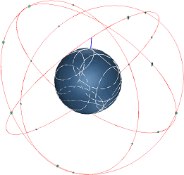 Through the network of satellites that orbit the track orbital, this system is possible to deliver sound quality with a better effect without resonance. but also how, satellite Geo is still better and more suitable for transmission that has a wide spectrum such as television.
 Through the network of satellites that orbit the track orbital, this system is possible to deliver sound quality with a better effect without resonance. but also how, satellite Geo is still better and more suitable for transmission that has a wide spectrum such as television.
Tuesday, September 9, 2008
Low Earth orbit-LEO
Low orbit is an orbit around the Earth between the atmosphere and the Van Allen radiation belt, with a low inclination angle. These limits are not defined exactly, but usually under 1,500 km above the surface of Earth. This orbit is usually located under the intermediate circular orbit (ICO) and far below the geostationary orbit. Orbital lower from here is not stable and will fall quickly because of the atmosphere of friction. A higher orbit from the orbital This is the subject of electronic failure early because of strong radiation and collecting cargo. Orbital inclination angle with a higher usually called a polar orbit. Objects in low Earth orbit to meet
 the gas atmosphere in the thermosphere (about 80-500 km above) or exosphere (approximately 500 km above), depending on the altitude orbit. Most of the flight space probe has been in LEO, including all the various space shuttle and space station mission; one exception is the suborbital test flights as early Mercury Project and the SpaceShipOne flight (which did not achieve the intended LEO), and Project Apollo missions to the Moon (which passes LEO ).
 the gas atmosphere in the thermosphere (about 80-500 km above) or exosphere (approximately 500 km above), depending on the altitude orbit. Most of the flight space probe has been in LEO, including all the various space shuttle and space station mission; one exception is the suborbital test flights as early Mercury Project and the SpaceShipOne flight (which did not achieve the intended LEO), and Project Apollo missions to the Moon (which passes LEO ).
Wednesday, August 20, 2008
Communications Satellites
The basic concept of communications satellites:
o Earth Station
Earth station is the radio communications station that is located on the ground and functions to communication with the space station.
oSatellite Communication
The communication between the satellite earth station through space or through artificial earth satellite passive.
oSatellite Links
It is a point of communication between earth station via a satellite link, and consists of the earth to the satellite (up-link) and a link from the satellite to the earth (down link). Station earth connected to the central switching from the communications network connecting via the link terresterial.
o Earth Station
Earth station is the radio communications station that is located on the ground and functions to communication with the space station.
oSatellite Communication
The communication between the satellite earth station through space or through artificial earth satellite passive.
oSatellite Links
It is a point of communication between earth station via a satellite link, and consists of the earth to the satellite (up-link) and a link from the satellite to the earth (down link). Station earth connected to the central switching from the communications network connecting via the link terresterial.
Saturday, August 9, 2008
Modulation Powerline Communication
PLC (Powerline communication) must work with the signal power / low frequency. Because of high frequency radiation can occur from power cable that can disrupt the frequency of others. This is contrary to the provisions of the SNR because of a variety of high interference can occur. The process of achieving a good SNR value of the constraints faced by the emergence of radiation effects power cable. But the problem can be solved with the methods of modulation:
1. Modulation CDM (Code division multiplexing) or spreads spectrum
Signal information can be scattered in a wide frequency range. The level of the signal information is made with very low expectations will not be subject to the noise level is very high in the PLC.
2. Modulation OFDM (Orthogonal Frequency division multiplexing)
Modulation method is quite stable. Modulastion efficiency can reach 5 bits per Hz higher modulation from the other.
1. Modulation CDM (Code division multiplexing) or spreads spectrum
Signal information can be scattered in a wide frequency range. The level of the signal information is made with very low expectations will not be subject to the noise level is very high in the PLC.
2. Modulation OFDM (Orthogonal Frequency division multiplexing)
Modulation method is quite stable. Modulastion efficiency can reach 5 bits per Hz higher modulation from the other.
Friday, July 25, 2008
PLC (Powerline communication) Applications
The connection to the Internet as a means to distribute data or voice (VoIP) by using the electricity network.
1.High speed digital Internet
Can be reached and to include all the world, quickly and securely through the Internet connection, e-commerce, e-mail, and e-banking.
2. telephony
The phone connection is very strong using the Internet, which provides security and quality of the conversation clear. We can also send and receive messages from the fax machine.
3.Smart Homes
And the use of the remote control in the home via the Internet allows household appliances such as refrigerators, heating systems and other.
4. Security
A system of security in both visual and motion detector can be monitored or to allow the owner or the safety and security.
5.Health Care Service
The monitoring of every person who needs the help of health PLC through an internet connection.
1.High speed digital Internet
Can be reached and to include all the world, quickly and securely through the Internet connection, e-commerce, e-mail, and e-banking.
2. telephony
The phone connection is very strong using the Internet, which provides security and quality of the conversation clear. We can also send and receive messages from the fax machine.
3.Smart Homes
And the use of the remote control in the home via the Internet allows household appliances such as refrigerators, heating systems and other.
4. Security
A system of security in both visual and motion detector can be monitored or to allow the owner or the safety and security.
5.Health Care Service
The monitoring of every person who needs the help of health PLC through an internet connection.
Wednesday, July 9, 2008
Global Positioning System (GPS)
 GPS is the Global Positioning System navigation equipment that is used to determine the position at any time and anywhere by using satellites. Function of the GPS satellites which are always / continuously send or emit code information used to know / identify the location on the earth.
Segments of the GPS:
space segment, user segment, and control segment.
Space segment
Consists of 24 satellites (21 active and 3 as a backup), each of which is the orbit distance with 11,000 miles above the surface of the earth.
User segment
Consists of tools recipient GPS signals from satellites.
Control segment of the earth from the station that serves as a checker to ensure that the GPS satellites to work properly. Examples in everyday life, used to know the search for the presence / position of someone, help in finding the existence of a car on the highway, to know the position of the aircraft, to know the speed of an object, and so forth.
Wednesday, June 25, 2008
Multiple Access of INTELSAT Satellite
 Satellite INTELSAT access using the 2 methods, namely TDMA and FDMA. Time Division Multiple Access with Direct Digital Interface (TDMA / DDI), Digital Speech Interpolation (TDMA / DSI) and Digital Speech Interpolation without.
TDMA is the method used to overcome the back-off and also more flexible in sharing between the satellite to the station and channel. With TDMA, the station can be full access to the satellite transponder with a time slot, so there is no intermodulation strengthening can be maximum, and although troughput high number of multiple access.
Method Frequency Division Multiple Access (FDMA) can be used for analog modulation (FM) or digital modulation (PSK). Location frequency used satellite Internet is the C-band and Ku-Band.
Saturday, June 7, 2008
INTELSAT Satellite
 INTELSAT Satellite was first launched on 28 June 1965, which was placed in geostationary orbit over the Atlantic ocean. Lunch and operated as the orbit Early Phase (LEOP) headquartered in Washington DC. To access the INTELSAT satellite, INTELSAT has the characteristics that vary for each earth station with the station type:
Standard A has a nominal G / T 35.0 dB / K and the operating frequency band at 6 / 4 GHz for international service.
Standard B has a nominal G / T 31.7 dB / K and the operating frequency band at 6 / 4 GHz for international service.
Standard C has a nominal G / T 37.0 dB / K and frequency bands operating in the 14/11 or 14/12 GHz GHz for international service.
Standard E, the Standard E-1 has a nominal G / T 25.0 dB / K, Standard E-2 has a nominal G / T 29.0 dB / K, Standard E-3 has a nominal G / T 34.0 dB / K and the operating frequency band at 14 / 11 GHz or 14/12 GHz for services to Intelsat Business Services (IBS), Intermediate Data Rates (IDR) international, Internet Trunking Service (ITS) and VSAT. using Turbo coding with QPSK / OQPSK (Standard E-1).
Standard F, Standard M-1 has a nominal G / T 22.7 dB / K, Standard F-2 has a nominal G / T 27.0 dB / K, Standard M-3 has a nominal G / T 29.0 dB / K and the operating frequency in the band 6 / 4 GHz for services to Intelsat Business Services (IBS), Intermediate Data Rates (IDR) international, Internet Trunking Service (ITS) and Turbo coding using VSAT with QPSK / OQPSK (Standard F-1).
Standard G, does not have a specific G / T segment for satellite Internet access services to domestic and international. This standard allows the use of the G modulation techniques and access to other, that is not in the Standard A and M and only the general characteristics of the RF limits.
Standard H, Standard H-2 has a nominal G / T 15.1 dB / K, Standard H-3 has a nominal G / T 18.3 dB / K, Standard H-4 has a nominal G / T 22.1 dB / K and the operating frequency in the band 6 / 4 GHz for services to Intelsat Business Services (IBS), Intelsat DAMA, the Internet Trunking Service (ITS) and Turbo coding using VSAT with QPSK / OQPSK.
Standard K, K-2 Standard has a nominal G / T 19.8 dB / K, K-3 standards have nominal G / T 23.3 dB / K, and in the operating frequency band, 14/11 or 14/12 GHz for services to Intelsat Business Services (IBS), the Internet Trunking Service (ITS) and Turbo coding using VSAT with QPSK / OQPSK.
Monday, May 26, 2008
Increasing Capacity In The System Cellular
There are several ways to increase the capacity of the system cellular.
Using Frequency reuse
Dense population of cells to be overloaded with the relocation frequency of cells that are not overloaded.
Conducting Cell-Splitting
Cells with dense population is doing cell splitting into several new cells into a new cluster of small to add more capacity. This is done by making changes in the parameters of the transmission link budget recalculate and also make a new design for the antenna height of the BTS.
Two types of cell splitting:
• Permanent Splitting: Cell of the permanent, it must be done to the planning cooked to the following matters:
1. The number of channel
2. Power transmitter
3. The frequency allocated
4. Determination of Cell Site
5. Traffic load
• Dynamic Splitting: This technique is also referred to as the "Real-time splitting" because cell division is done only at the time it needed to overcome the traffic density that is temporary

Conducting Sectoring
Dividing cells become sectors, usually 3 sectors (each 120 °) or 6 sectors (each 60 °). Each sector will be served by a directional antenna and the frequency varies. Interesting directional antenna to reduce co-channel, which makes a smaller cluster with a larger capacity.
Using Frequency reuse
Dense population of cells to be overloaded with the relocation frequency of cells that are not overloaded.
Conducting Cell-Splitting
Cells with dense population is doing cell splitting into several new cells into a new cluster of small to add more capacity. This is done by making changes in the parameters of the transmission link budget recalculate and also make a new design for the antenna height of the BTS.
Two types of cell splitting:
• Permanent Splitting: Cell of the permanent, it must be done to the planning cooked to the following matters:
1. The number of channel
2. Power transmitter
3. The frequency allocated
4. Determination of Cell Site
5. Traffic load
• Dynamic Splitting: This technique is also referred to as the "Real-time splitting" because cell division is done only at the time it needed to overcome the traffic density that is temporary

Conducting Sectoring
Dividing cells become sectors, usually 3 sectors (each 120 °) or 6 sectors (each 60 °). Each sector will be served by a directional antenna and the frequency varies. Interesting directional antenna to reduce co-channel, which makes a smaller cluster with a larger capacity.
Tuesday, April 15, 2008
Interference On Radio Waves
Communications that occur in the sellular using radio waves. Radio communication utilizing electromagnetic waves in the transmission of data on the air interface. The data is passed over the interface is not always accepted in the Receiver intact, but the data will have a disability.
Likewise for the transmission of the signal (the conversation) in the water interface will have several obstacles that lead to sound/voice can not be accepted by both.
Constraints in the transmission of signals that there may be caused by:
Pathloss
Decrease the signal strength that occurs depending on the distance between the transmitter and Receiver. So that MS is beyond the reach of the BTS.
Time Alligment
Time used for the transmission of MS signals that are influenced by distance from the BTS to MS.
Rayleigh Fading
Interference signal reception / signal caused by the weak signals received are some signals that the reflection from the nearest object and not a signal that is received directly.
Time Dispersion
Transmission constraints that occur when the digital signal to reach the same Receiver in a different time because there is a rebound occurs that causes a signal not synchronized.
Likewise for the transmission of the signal (the conversation) in the water interface will have several obstacles that lead to sound/voice can not be accepted by both.
Constraints in the transmission of signals that there may be caused by:
Pathloss
Decrease the signal strength that occurs depending on the distance between the transmitter and Receiver. So that MS is beyond the reach of the BTS.
Time Alligment
Time used for the transmission of MS signals that are influenced by distance from the BTS to MS.
Rayleigh Fading
Interference signal reception / signal caused by the weak signals received are some signals that the reflection from the nearest object and not a signal that is received directly.
Time Dispersion
Transmission constraints that occur when the digital signal to reach the same Receiver in a different time because there is a rebound occurs that causes a signal not synchronized.
Sunday, April 6, 2008
The Beautiful Fountain
This is a very beautiful place, where we can see the water fountain unique. That all people can see the image directly but through this we can see, although not directly to the place. I may never be able to go to a beautiful place, as far away and required a lot of money to go. Also, some people may have to go to that place for a vacation to enjoy the scenery beautiful fountain.
 This fountain is located in Tivoli
 This fountain is located in Barcelona
 This fountain is located in Tivoli
Maybe one day I will go see a fountain that is beautiful.
 This fountain is located in Tivoli
 This fountain is located in Barcelona
 This fountain is located in Tivoli
Maybe one day I will go see a fountain that is beautiful.
Subscribe to:
Posts (Atom)